AreaPal vs AreaMap
Measure Land & Acres.
By the AreaPal team · Updated
Short answer
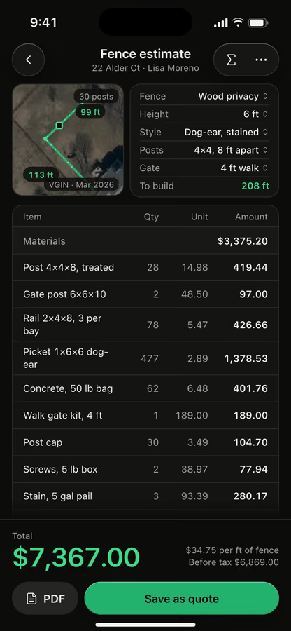
Both measure land on a satellite map or with a GPS walk, and both estimate materials from the shape. AreaMap comes in 13 languages. AreaPal prices 32 jobs from your own price book and sends a quote your customer approves in the browser.
We make AreaPal, so we say so. What we write about AreaMap: Measure Land & Acres comes from its US App Store listing, checked November 2026. We don't rate other apps.
At a glance · from AreaMap’s listing, Nov 2026
Both apps
- Tap corners or walk with GPS
- Material estimates from the shape
- PDF reports and KML export
AreaMap
- 13 app languages
- A marker that copies exact coordinates
AreaPal adds
- Quotes your customer approves online
- Estimates for 32 jobs, from your price book
- DXF and Shapefile export
Side by side
What we could check.
Only rows where AreaMap’s listing says what it does. Anything we couldn't check is left out.
Feature
 AreaPal
AreaMap: Measure Land & Acres
Tap the corners on a satellite map
AreaPalDrag with a loupe, snap to 90°, undo and redo
AreaMapDrag corners, add points, undo and redo
Walk with the screen locked
AreaPalLive accuracy, corner averaging, error band
AreaMapWalk or drive, pause, the shape closes at the end
Maps
AreaPalSatellite, hybrid, standard, 3D and Look Around
AreaMapSatellite, hybrid, standard, 3D and Look Around
Estimates from the shape
AreaPal32 jobs plus any other, with labor, markup and tax
AreaMapFence posts and rails, sod, seed, mulch, soil, gravel, concrete
PDF report
AreaPalReport with the map and sizes, and a branded quote PDF
AreaMapMap, scale, sides, coordinates, estimates, photos
Saved areas
AreaPalFolders, colors, notes, photos, iCloud sync
AreaMapNames, notes, color groups, photos
Export
AreaPalKML, KMZ, GPX, GeoJSON, CSV, DXF, Shapefile
AreaMapKML, GPX, GeoJSON, CSV, map image
Source for AreaMap: its US App Store listing, checked November 2026. No prices on this page for either app.
Also in AreaPal
What else AreaPal does.
Not compared: we couldn't confirm these on AreaMap’s listing, so we don't say whether it has them.
Walk with the screen lockedLive accuracy, corner averaging, error band
Imagery date always shownApple and free national aerials to compare
Every unitAcres, square feet, hectares and local units
Cut-outsGross and net, a pool or pond taken out
Slope and elevationSurface 2.49 ac, flat 2.47 ac
CoordinatesDMS, UTM and MGRS, typed or pasted
Import and exportKML, KMZ, GPX, GeoJSON, CSV; also DXF and Shapefile out
iCloud sync, no accountYour areas stay in your own iCloud
Estimates for 32 jobsPlus any other job, from your price book
Quotes approved onlineUp to 3 options, signed in the customer's browser
Which one is for youPick by what you do
Pick by what you do
after you measure.
AreaMap: Measure Land & Acres
May suit you if
- You want the app in one of 13 languages
- A material count is as far as you go
- You already keep your areas there and they work for you
AreaPal
May suit you if
- You send customers a quote with up to 3 options
- You price from your own materials, labor rate, markup and tax
- You quote fence, sod, gravel, snow and 28 more jobs
Photos by Amanda Costelloe, FRAEM GmbH on Unsplash.
FAQ
Questions, answered.
Is AreaPal the same app as AreaMap?
No. The names are close, but AreaPal is made by 8 Ventures and has no link to AreaMap or its developer. We make AreaPal, so read this page knowing that.
What is the difference between AreaMap and AreaPal?
Both measure land and estimate materials. AreaPal goes on to the quote: up to 3 options, sent as a link the customer opens in the browser, signs with a finger and approves.
Can I move my areas from AreaMap to AreaPal?
AreaMap's listing says it exports KML, GPX, GeoJSON and CSV. AreaPal imports all four, as well as KMZ.
Is AreaPal a legal survey?
No. On the satellite map it's close enough to plan, buy and price, and a GPS walk shows the area with its error band, like 2.47 ac ± 0.04. For a legal boundary, hire a licensed surveyor.
Compare
All comparisonsOther comparisons
AreaPal vs GPS FieldsOffline and 49 languages, or estimates and quotes.Read it AreaPal vs Measure MapTwo map measuring apps, row by row, from Measure Map Pro's listing.Read it AreaPal vs PlanimeterWhat a planimeter is, then the Planimeter app row by row.Read it AreaPal vs FieldCalcTwo field measuring apps, row by row, from FieldCalc's listing.Read it AreaPal vs MapulatorOffline map measuring, or estimates and quotes.Read it
AreaPal for iPhoneMeasure it, then price it.

Measure it, then price it.
From the same app.
Draw or walk the land, pick the job, and send a quote your customer approves from a link.