AreaPal vs Planimeter
GPS Area Measure.
By the AreaPal team · Updated
Short answer
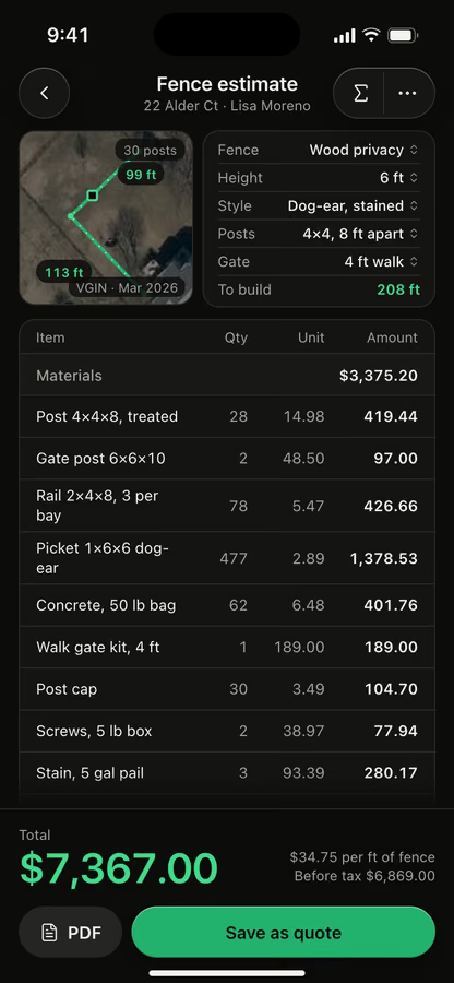
Both measure area and distance on a satellite map or by GPS, and both save KML files. Planimeter adds a stylus draw mode, bearings and the angle between lines. AreaPal adds estimates for 32 jobs and quotes your customer approves in the browser.
We make AreaPal, so we say so. What we write about Planimeter GPS Area Measure comes from its US App Store listing, checked November 2026. We don't rate other apps.
At a glance · from Planimeter’s listing, Nov 2026
Both apps
- Measure area on a satellite map
- Walk the boundary with GPS
- KML files to save and share
Planimeter
- A stylus draw mode
- Bearings and the angle between lines
AreaPal adds
- Estimates for 32 jobs
- Quotes your customer approves online
- Cut-outs for pools and buildings
What is a planimeterFrom a wheel on paper
From a wheel on paper
to a tap on the map.
A planimeter is a drafting instrument that measures the area of a shape on paper. You trace the outline on a map or plan with a pointer, and a measuring wheel adds up the area as it rolls. Multiply the reading by the map's scale and you have the area on the ground.
Engineers, foresters and surveyors used polar, roller and later digital planimeters for well over a century. They work, but only on a drawing at a known scale, and every outline is traced by hand.
Planimeter apps, and searches for a Google planimeter or a planimeter online, do the same job on a digital map: tap the corners and the app works out the area. AreaPal measures on Apple satellite imagery and free national aerials, with the imagery date shown, or as you walk the boundary with GPS. The North pasture comes out at 2.47 ac with a 1,312 ft perimeter and every side labeled.
Side by side
What we could check.
Only rows where Planimeter’s listing says what it does. Anything we couldn't check is left out.
Feature
 AreaPal
Planimeter GPS Area Measure
Measure area on the satellite map
AreaPalSatellite, hybrid, standard and 3D maps; tap the corners
PlanimeterMap or satellite view, points added by touch
Measure by walking with GPS
AreaPalScreen locked, live accuracy, area with its error band
PlanimeterGPS tracking, with pins placed by hand too
Points from typed coordinates
AreaPalType each corner in decimal, DMS, UTM, MGRS and more
PlanimeterAdd points by latitude and longitude
Search for a place
AreaPalBy address or coordinates
PlanimeterAddress search and current location
Units
AreaPalEvery unit, local ones too: alqueire, guntha, bigha
Planimeterm, km, feet, yards, miles, ha, acres
Notes on the map
AreaPalPins with a note and a photo
PlanimeterNotes mode
Files
AreaPalExport KML, KMZ, GPX, GeoJSON, CSV, DXF, Shapefile and PDF
PlanimeterSave and share KML, or save TXT
Source for Planimeter: its US App Store listing, checked November 2026. No prices on this page for either app.
Also in AreaPal
What else AreaPal does.
Not compared: we couldn't confirm these on Planimeter’s listing, so we don't say whether it has them.
Walk with the screen lockedLive accuracy, corner averaging, error band
Imagery date always shownApple and free national aerials to compare
Every unitAcres, square feet, hectares and local units
Cut-outsGross and net, a pool or pond taken out
Slope and elevationSurface 2.49 ac, flat 2.47 ac
CoordinatesDMS, UTM and MGRS, typed or pasted
Import and exportKML, KMZ, GPX, GeoJSON, CSV; also DXF and Shapefile out
iCloud sync, no accountYour areas stay in your own iCloud
Estimates for 32 jobsPlus any other job, from your price book
Quotes approved onlineUp to 3 options, signed in the customer's browser
Which one is for youPick by what you do
Pick by what you do
after you measure.
Planimeter GPS Area Measure
May suit you if
- You want bearings and the angle between lines
- You like drawing outlines with a stylus
- Areas and distances are all you need
AreaPal
May suit you if
- You price work from what you measure: fence, sod, gravel, snow and 28 more jobs
- You walk boundaries and want the error band next to the area
- You send customers a quote to approve from a link
Photos by Kerin Gedge, Crispin Jones on Unsplash.
FAQ
Questions, answered.
What is a planimeter?
A drafting instrument that measures the area of a shape on paper. You trace the outline and a wheel records the area, which you scale up to the map. Planimeter apps now do the same on a satellite map.
Is there a planimeter app for iPhone?
Yes. Planimeter GPS Area Measure is one, and AreaPal is another. AreaPal measures on the satellite map or on foot, then turns the shape into an estimate and a quote. It runs on iPhone, and on iPad and Mac as the same app. There is no Android version.
Is there a Google planimeter or a planimeter online?
Those searches usually mean measuring area on a satellite map. AreaPal is not a Google product, and the AreaPal website doesn't measure land. The app does, on Apple satellite imagery and free national aerials, with the imagery date shown.
Is AreaPal made by the Planimeter team?
No. AreaPal is made by 8 Ventures and has no link to Planimeter GPS Area Measure or its developer, VisTech.Projects LLC. We make AreaPal, so read this page knowing that.
Can I move my measurements from Planimeter to AreaPal?
Planimeter's listing says it saves and shares KML files. AreaPal imports KML, as well as KMZ, GPX, GeoJSON and CSV.
Compare
All comparisonsOther comparisons
AreaPal vs GPS FieldsOffline and 49 languages, or estimates and quotes.Read it AreaPal vs Measure MapTwo map measuring apps, row by row, from Measure Map Pro's listing.Read it AreaPal vs AreaMapTwo land apps with estimates. AreaPal goes on to the quote.Read it AreaPal vs FieldCalcTwo field measuring apps, row by row, from FieldCalc's listing.Read it AreaPal vs MapulatorOffline map measuring, or estimates and quotes.Read it
AreaPal for iPhoneMeasure it, then price it.

Measure it, then price it.
From the same app.
Draw or walk the land, pick the job, and send a quote your customer approves from a link.